Stonehenge Landscape: Avebury, Woodhenge & Nearby Sites Guide
The Stonehenge UNESCO World Heritage Site encompasses a wider prehistoric landscape containing dozens of monuments beyond the stone circle itself. The most significant include Avebury (the world’s largest stone circle, 30km north), Silbury Hill (Europe’s largest prehistoric mound), West Kennet Long Barrow, Woodhenge (a timber circle 3km from Stonehenge), and Durrington Walls. Most are free to visit. Salisbury Cathedral and Old Sarum are the most rewarding non-prehistoric additions to a Stonehenge day.
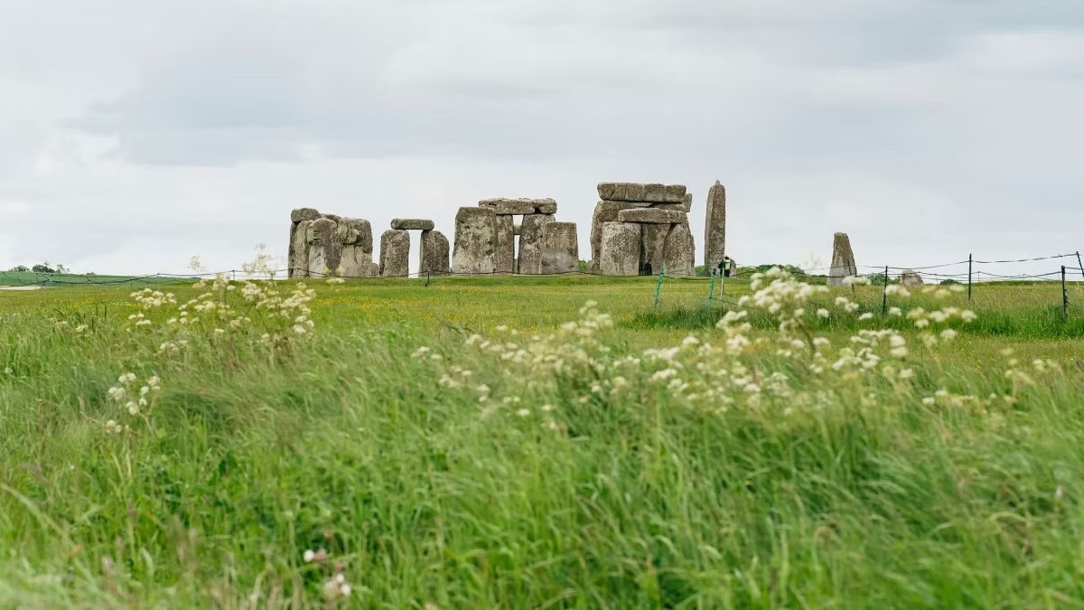
Stonehenge exists in a landscape that was sacred to prehistoric communities across approximately 2,000 years. The monument is the most famous element of a complex that extends across a 25 square-kilometre area of Wiltshire chalk downland — and visiting that wider landscape, rather than just the stone circle, transforms your understanding of what Stonehenge is and why it was built here. This guide covers every significant site in the landscape, how to reach each, and how to combine them effectively in a day.
The World Heritage Site
The UNESCO World Heritage designation for Stonehenge encompasses two distinct areas of Wiltshire:
- The Stonehenge landscape: approximately 25 square kilometres centred on the stone circle, containing the Avenue, the Cursus, Woodhenge, Durrington Walls, and hundreds of Bronze Age burial mounds
- The Avebury landscape: approximately 25 square kilometres around the village of Avebury, 30 kilometres north, containing Avebury henge and stone circle, Silbury Hill, West Kennet Long Barrow, Windmill Hill, and the Beckhampton and West Kennet Avenues
Together, the two landscapes represent approximately 2,000 years of continuous Neolithic and Bronze Age monument-building in a region that was clearly of extraordinary spiritual and social significance to prehistoric Britain.
Sites In and Around the Stonehenge Landscape
The Avenue (Free, accessible via walking route from Stonehenge)
The Avenue is a ceremonial approach road connecting Stonehenge to the River Avon, approximately 2.8 kilometres to the south-east. Constructed as parallel banks and ditches approximately 12 metres apart, it was built around 2300 BCE as the final approach to the monument.
Its significance: the Avenue’s straight final section near Stonehenge aligns precisely with the midsummer sunrise / midwinter sunset axis — the same alignment as the monument itself. Recent excavations revealed that this alignment was not arbitrary but followed natural periglacial stripes (ridges formed by ice-age freezing cycles) that already pointed towards the solstice. The builders of Stonehenge may have chosen this site partly because nature had already oriented the landscape towards the rising midsummer sun.
The Avenue is visible from the stone circle viewing path as a linear earthwork extending north-east. The walking route from the Visitor Centre to the stones passes alongside part of it.
Woodhenge (Free, 3km from Stonehenge, accessible by car or walking)
Woodhenge was a Neolithic timber circle monument, built and used around 2300 BCE — contemporary with the main phase of Stonehenge’s sarsen construction. It lies approximately 3 kilometres north-east of Stonehenge on the B3086 and is free to visit.
The original timber uprights no longer exist, but their positions are marked by low concrete posts in six concentric ovals — a pattern whose shape closely mirrors the stone settings at Stonehenge. The monument is oriented towards the midsummer sunrise. Evidence of ritual feasting and, in one case, a child burial have been found here.
Woodhenge is worth the brief detour from Stonehenge, particularly for visitors who want to see the wider range of monument types in the landscape. It takes approximately 15–20 minutes to walk around.
Durrington Walls (Free, adjacent to Woodhenge, visible from road)
Durrington Walls is the largest henge monument in Britain — a circular earthwork approximately 500 metres in diameter, enclosing what is now largely invisible beneath farmland. It was built around 2500 BCE and is believed to have been the settlement of the people who built Stonehenge.
Archaeological excavation by Mike Parker Pearson’s Stonehenge Riverside Project between 2004 and 2010 found evidence of large-scale feasting (pig and cattle bones), seasonal occupation, and house structures — suggesting that thousands of people converged on Durrington Walls in midwinter to feast and prepare for the ceremonies at Stonehenge a few kilometres to the south-west.
Within Durrington Walls was a timber circle known as the Southern Circle, oriented towards the winter solstice sunrise — opposite to Stonehenge’s summer solstice orientation. Parker Pearson has proposed that Durrington Walls and Stonehenge formed a complementary pair: the living world and the ancestor world, connected by the River Avon and the Avenue.
The henge earthwork is visible from the road. A small car park allows access to footpaths around the site. Entry is free.
The Bronze Age Barrows (Free, visible from Stonehenge and surrounding roads)
The ridges surrounding Stonehenge contain the densest concentration of Bronze Age burial mounds in Britain — approximately 300 round barrows grouped in cemeteries on the horizons visible from the stone circle.
The most significant groups are:
- King Barrow Ridge — a line of prominent barrows to the north-east, visible from the stone circle and straddling the walking route
- Normanton Down — a cemetery of particularly rich burials to the south, containing the Bush Barrow — possibly the most important Early Bronze Age burial ever found in Britain, containing a gold lozenge, bronze daggers, and a decorated sceptre
These barrows are on National Trust land and visible from public footpaths. Most are grassed-over mounds with no visible interior — but their concentration and deliberate positioning on the skylines around Stonehenge tells a story of a community that treated the landscape around the monument as sacred space for hundreds of years.
Avebury: The Essential Companion
Avebury is 30 kilometres north of Stonehenge (approximately 40 minutes by car) and is, in the opinion of many visitors who make the journey, the more extraordinary experience of the two.
What Avebury is:
- The largest prehistoric stone circle in the world — containing three stone circles within a circular earthwork bank and ditch nearly a mile in circumference
- A National Trust property managed jointly with English Heritage
- A living village: the Red Lion pub, thatched cottages, and a church all sit inside the henge earthwork
- Free to visit — no admission charge
How Avebury compares to Stonehenge:
Avebury is 16 times the area of Stonehenge. The outer circle originally contained approximately 100 standing stones, the largest weighing over 100 tonnes. Unlike Stonehenge, there is no barrier — visitors walk freely among the standing stones, touching them, sitting near them, and experiencing their scale without any managed distance.
The monument is nearly 1,000 years older than Stonehenge’s sarsen circle (built from around 2850 BCE). The walking experience — across open grassland, around and between enormous standing stones, with the village visible at the centre — is fundamentally different from Stonehenge’s structured circular path.
What else is at Avebury:
- Silbury Hill — 1 kilometre south of Avebury, the largest prehistoric artificial mound in Europe (40 metres high, 160 metres diameter). Its purpose is unknown. Entry to the hill itself is not permitted, but the view from the road is dramatic.
- West Kennet Long Barrow — 2 kilometres south of Avebury, one of the largest and best-preserved Neolithic burial chambers in Britain, built around 3650 BCE. Visitors can enter the chambers. The site is free and managed by English Heritage.
- West Kennet Avenue — paired standing stones running 2.5 kilometres south-east from Avebury towards the Sanctuary — the monument at the Avenue’s southern end. Walking the first 800 metres (where the stones remain) is one of the most atmospheric experiences in the landscape.
- The Alexander Keiller Museum (National Trust) — in the village, displays finds from Avebury’s excavations and provides background on the landscape monuments.
Getting to Avebury:
By car: 40 minutes north of Stonehenge via A360 and A4. Parking in the village (National Trust, small charge).
By tour: Specialist tours from Bath, London, and Salisbury include Avebury — see our guides to Bath-departing tours and the Special Access Evening Tour.
Salisbury Cathedral and Old Sarum (15km from Stonehenge)
For visitors who want to combine Stonehenge’s prehistoric landscape with medieval and Roman history, Salisbury provides two of the finest heritage sites in England.
Salisbury Cathedral: Built between 1220 and 1320, it has Britain’s tallest spire (123 metres) and houses one of the four surviving original copies of Magna Carta (1215) — the best-preserved copy in existence. The medieval clock, dating from 1386, is the oldest working mechanical clock in the world. Open daily; admission charged. Approximately 15km south of Stonehenge.
Old Sarum: An Iron Age hillfort that later became a Roman town, Norman castle, and the original site of Salisbury Cathedral before the whole city was relocated to the valley in the 13th century. Managed by English Heritage; admission charged. Exceptional views across the plain towards Stonehenge are possible on clear days. The Stonehenge Tour Bus stops at Old Sarum on the route between Salisbury and the monument.
Practical Guide to Combining Sites
Stonehenge + Avebury (full day)
Allow 2 hours at Stonehenge, 2–3 hours at Avebury (including the stone circle, Silbury Hill viewpoint, West Kennet Long Barrow, and at least the first section of the West Kennet Avenue), and 1 hour driving. Total: approximately 7–8 hours.
From Bath: Stonehenge & the Cotswolds Day Tour
Stonehenge + Salisbury Cathedral + Old Sarum (full day)
Allow 2 hours at Stonehenge, 1 hour at Old Sarum, 1.5 hours at Salisbury Cathedral, 30–40 minutes driving. Total: approximately 6–7 hours.
From Salisbury: Stonehenge Private Guided Tour
Stonehenge + Woodhenge + Durrington Walls (half-day extension)
Both Woodhenge and Durrington Walls are within 4 kilometres of Stonehenge. Add 1 hour to any Stonehenge visit to include a brief stop at each. Entry is free. Best done by car.
Frequently Asked Questions
Is Avebury free to visit?
Yes — walking among the Avebury stone circles is free. The Alexander Keiller Museum in the village charges a small admission. Parking in the National Trust car park has a modest fee.
Is Avebury better than Stonehenge?
Many visitors who see both describe Avebury as the more affecting experience — the freedom to walk among the stones, the scale of the henge, and the combination with Silbury Hill and West Kennet Long Barrow create a richer immersion in the prehistoric landscape. It is a different experience rather than a better or worse one.
Is West Kennet Long Barrow worth visiting?
Yes — strongly recommended. You can enter the burial chambers of a 5,650-year-old tomb. The site is free, usually uncrowded, and provides a visceral connection to Neolithic burial practices that the Stonehenge Visitor Centre’s exhibition can only describe.
How far is Avebury from Stonehenge?
Approximately 30 kilometres by road — about 40 minutes by car. No direct public transport connects the two; a car or guided tour is necessary.
Are the Bronze Age barrows visible during a standard Stonehenge visit?
Yes — several barrow groups are visible from the stone circle viewing path on the surrounding ridges. The walking route from the Visitor Centre to the stones passes close to the King Barrow Ridge. The audio guide describes the landscape monuments visible from the path.